Q.1. Fill in the blank choosing the correct alternative : (4 Marks)
(1) The 82°30’E longitude is the Indian Standard Time longitude which passes through ...................... .
(a) Allahabad
(b) Ahmedabad
(c) Hyderabad
(d) Muzaffarabad
(2) Most part of Brazil lies in the ............... zone.
(a) polar
(b) tropical
(c) subtropical
(d) temperate
(3) The Islands in the Bay of Bengal are called ...................... islands.
(a) Andaman and Nicobar
(b) Maldives
(c) Corsola
(d) Lakshadweep
(4) Brazil gained independence in .............. .
(a) 1890
(b) 1980
(c) 1822
(d) 1820
Q.2. Arrange the sentences in correct sequence : (4 Marks)
(a) South-West Monsoon Winds move towards the Himalayas. Their moisture carrying capacity increases.
(b) Low pressure area developed in Punjab Plains and the Thar Desert of Rajasthan because of high temperature in summer.
(c) While blowing from the north-east towards the Indian Ocean, these winds bring rainfall again to the same part of the Peninsula. This is the retreating monsoon season in India.
(d) Obstruction caused by the Eastern and Western Ghats causes more rainfall in the coastal areas. The rainfall reduces in the leeward side of the hill.
Answer:
(a) Low pressure area developed in Punjab Plains and the Thar Desert of Rajasthan because of high temperature in summer.
(b) Obstruction caused by the Eastern and Western Ghats causes more rainfall in the coastal areas. The rainfall reduces in the leeward side of the hill.
(c) South-West Monsoon Winds move towards the Himalayas. Their moisture carrying capacity increases.
(d) While blowing from the north-east towards the Indian Ocean, these winds bring rainfall again to the same part of the Peninsula. This is the retreating monsoon season in India.
Q.3. Differentiate between : (Any 2) 4
(a) Water transport in the Amazon and the Ganga river.
(b) Location of India and Brazil
(c) IST and BRT
Answer:
(a)
Water transport in the Amazon River
|
Water Transport in the Ganga River
|
River Amazon is navigable throughout its course due to its gentle slope.
|
River Ganga is navigable only in its middle and lower course which is gentler as compared to its upper course.
|
Boats ply from Equitos in Peru to its mouth i.e. approx. 3700 km
|
Boats ply from Allahabad to Haldia. i.e. approx. 1620 km
|
River Amazon is used for navigation between Brazil and neighbouring countries.
|
River Ganga is used for inland transportation.
|
(b)
Location of India
|
Location of Brazil
|
India is located at 8°4’N to 37°6’N latitude and between 68°7’E to 97°25’E longitudes.
|
Brazil is located at 5°15’N to 33°45’S latitudes and between 34°45’W to 73°48’W.
|
It is located in the northern and eastern hemispheres.
|
Some part of Brazil lies in the northern hemisphere, while most of it lies in the southern hemisphere.
|
India is located in the southern part of the Asian continent.
|
Brazil is located in the northern part of South American continent.
|
IST
|
BRT
|
IST is the Indian Standard Time or India Time.
|
BRT is the Brasilia Time / Brazil Time. (Standard Time)
|
India has only one standard time zone.
|
Brazil has four time zones.
|
The official IST is 82.5° E longitude which passes through Mirzapur near Allahabad, Uttar Pradesh.
|
The official BRT is GMT - 03 which passes through Brazilia, the national capital city.
|
IST is 5hrs 30mins ahead of Greenwich Meridian Time as India is in the eastern hemisphere
|
BRT is 2,3,4, or 5 hours behind Greenwich Meridian Time as Brazil is in the western hemisphere.
|
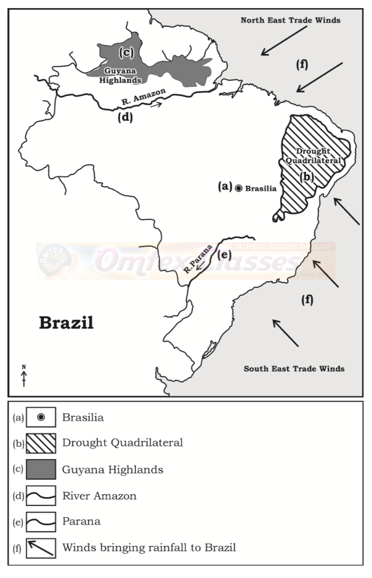
Q.4. (A) On an outline map of Brazil fill the given information and make 4a legend : (Any 4)
(a) New capital city that attracts tourists.
(b) Drought Quadrilateral or Rain Shadow region in Brazil.
(c) Guyana Highlands
(d) River Amazon
(e) A south-flowing river important for waterways.
(f) Winds bringing rainfall to Brazil.
Answer:
Q.4. (B) Read the map of India given and answer the questions given 4 below : (Any 4)

Questions:
(a) Calculate the difference between the two longitudinal extremes of mainland India.
(b) Is the longitudinal extent of India more than Brazil ? Why ?
(c) Which longitude in India is called the Indian Standard Time (IST)?
(d) What is the difference between IST and the GMT?
(e) How many local times are there in India?
(f) Identify two neighbouring countries to the east of India.
Answer:
(a) The difference between the two longitudinal extremes of east and west mainland India is about 30o.
The difference between the two longitudinal extremes of east and west mainland Brazil is about 39o.
(b) No, the longitudinal extent of India is not more than Brazil because Brazil longitudinal extent is 39o and that of India's is approximately 30o.
(c) The 82°30’ E longitude is called Indian Standard Time (IST).
(d) The IST time is 5 hours and 30 minutes ahead of the GMT.
(e)There is only one local time in India.
(f) Two neighbouring countries to the east of India are Bangladesh and Myanmar.
Q.5. Give geographical reasons : (Any 2) 6
(a) India is looked upon as a young country.
Answer:
(i) The proportion of youth in India’s population is high.
(ii) This forms the major part of a working population.
(iii) According to 2011 census the percentage of working population is more than 50 %.
(iv) Hence, India is looked upon as a young country.
(b) India’s contribution of tourism to its GDP appears lesser than Brazil
and population engagement seems higher.
and population engagement seems higher.
Answer:
(i) The number of international tourists visiting India in 2015 was more than that of Brazil.
(ii) Apart from this, the proportion of Indian population engaged in tourism is higher than that of Brazil.
(iii) But the share of tourism sector in India's GDP is less than that of Brazil.
(iv) ThisisbecausetheGDPofIndiaishigherthanBrazil'sandsimilarly its population is more than Brazil.
So the contribution of tourism to India's GDP appears lesser than Brazil's and population engagement seems higher.
(c) Eco-tourism is being developed more in Brazil.
Answer
(i) Ecotourism means responsible travel to natural areas that conserves the environment.
(ii) Brazil has the largest number of vegetation species in the world including Amazon, the largest rainforest of the world and a great diversity of wild life.
(iii) It has clean white sand beaches, attractive seacoasts, beautiful islands and orchards.
Looking at the sensitivity of the natural resources in Brazil, Eco tourism is being developed here.
(d) Snowfall doesn't always occur in Brazil.
Answer:
(i) Because of the vast latitudinal extent of Brazil, it experiences a wide range of climatic variations. Near the equator it is hot, while temperate type of climate is found near Tropic of Capricorn.
(ii) Considering the temperatures in Brazil, the northern part of Brazil is hot while the temperatures in the southern part are comparatively lower.
(iii) It generally snows in those areas lying in the temperate or polar regions or in the mountainous regions of very high altitude.
(iv) Snowfalldoesoccurbutisonlyconfinedtohigherelevationsinthesouthern states of Rio Grande Do Sul, Parana and Santa Catarina.
(v) Most part of the country lies in the tropical zone which experiences
a hot and humid climate.
a hot and humid climate.
So snowfall doesn't always occur in Brazil and is considered a rare
phenomenon.
phenomenon.
Q.6. (A) Draw a multiple bar graph to represent the data and answer the 6 following questions :
Population engaged in tourism and the contribution of tourism in GDP of India and Brazil (2016)

(a) What does the graph show?
(b) Which country’s tourism has a larger share in the contribution
towards GDP?
towards GDP?
(c) Which country has a larger population engaged in tourism sector but
contributes lesser in GDP?
contributes lesser in GDP?
Answer:

(a) The graph shows (i) The percentage of population engaged in tourism and (ii) the contribution of tourism in GDP of both Brazil and India.
(b) Brazil’s tourism has a larger share in the contribution towards GDP.
(c) India has a larger population engaged in the tourism sector but contributes less in GDP.
OR
Q.6. (B) Study the following graph and answer the questions based on 6 it :

(a) Identify the graph, what information is provided in it ?
(b) Which country has a lower percentage of population engaged in tertiary sector ? How much is it ?
(c) In which country is the share of secondary activities more in the GDP? How much is it ?
(d) In which country is the share of primary sector lesser in the GDP ? How much is it ?
(e) Which sector in India is least efficient. Explain.
(f) Can we say that India is an industrial economy like Brazil. Give one reason.
Answer:
(a) It is a Compound Bar Graph. The graph shows the contribution of various sectors in the National Income and the percentage of population engaged in various sectors in India, Brazil in the year 2016.
(b) India has a lower percentage of population engaged in tertiary sector. It is about 27%.
(c) Share of the secondary activities in the GDP is more in Brazil. It is about 27.5%.
(d) Brazil has a lesser share of primary sector in GDP. It is only about 5.5%.
(e) Primary sector in India is least efficient because in India almost 50%population is engaged in the primary sector, but its contribution to the GDP is only about 18%.
(f) No, India is not an industrial economy like Brazil. This is because about half the population about (48.8%) is engaged in the primary sector.
Q.7. Answer the following in detail : (Any 2)
(a)
(i) Arun called his mother from Digboi at 7 am. At what local time will
his mother pick up his call at Jaisalmer? (1 Mark)
(ii) It is 12 noon at Brasilia. What would be the standard time in India ? (1 Mark)
(iii) A plane leaves Brasilia at 11 a.m. on 31st December. The plane crosses 0° Meridian and reaches Vladivostok via New Delhi. Tell the local time, date and day at New Delhi and Vladivostok when the plane leaves Brasilia. (2 Marks)
Answer:
(a)
(i) Digboi's longitude 95° 63’ E [7.00 am]
Jaisalmer's longitude − 70° 90’ E
24° 73’
Difference in the number of longitudes = Approximately 25°.
Time difference = 25° × 4 minutes = 100 minutes.
(i.e.) 1 hour and 40 minutes
24° 73’
Difference in the number of longitudes = Approximately 25°.
Time difference = 25° × 4 minutes = 100 minutes.
(i.e.) 1 hour and 40 minutes
Digboi is ahead of Jaisalmer, being in the Eastern part of India. So, if it is 7.00am at Digboi, it will be 5.20 am at Jaisalmer.
(ii) If it is 12 noon at Brasilia, it would be 8.30 p.m. at Delhi. (Since India is 81⁄2 hours ahead of Brazil)


(b) Compare the climates of Brazil and India.
Answer:
Climate of India
|
Climate of Brazil
|
India has a monsoon type of climate
|
Brazil has a tropical climate to the north and temperate climate to the south.
|
The southern part of India lies in the Tropics so the temperature is high in the south and comparatively low in the north. i.e. Temperature decreases from south to north.
|
The northern part of Brazil lies in the tropics so the temperature is high in the north and comparatively low in the south i.e. Temperature decreases from north to south.
|
India receives rain from the South West Monsoon Winds and the North East Monsoon Winds.
|
Brazil receives rain from the South East and North East Trade Winds.
|
It receives orographic rainfall.
|
It receives convectional and orographic type of rainfall.
|
The western part of Rajasthan, Gujarat and eastern side of the Western Ghats receive less rain.
|
The north eastern part of the Brazilian highlands is a rain shadow region.
|
Tropical cyclones are a frequent phenomena.
|
Tropical cyclones are a rare phenomena.
|
(c) Which are the major water divides of India? Give Example.
Answer:
A mountain or an upland which separates two drainage basins is known as Water Divide. The major Water Divides of India are :
(i) Western Ghats : The Western Ghats acts as a water divide and
separates the west flowing rivers like Zuari, Mandvi, Vaitarna draining into the Arabian Sea, from the east flowing rivers likeGodavari, Krishna and Kaveri draining into the Bay of Bengal.
(ii) Vindhya ranges : It divides the drainage basin of the River Ganga and the River Narmada.
(iii) Aravali ranges : The Aravalis separates the west flowing river Luni from the east flowing River Banas.
(iv) Satpuda ranges : The Satpudas separate the Narmada drainage basin and the Tapi drainage basin.
(d) A dense network of railways has developed in the North Indian Plains.
Answer:
(i) Railway is a cheap and speedy mode of transport as compared to other modes of transport.
(ii) The North Indian Plains have a vast leveled land which is ideal for railways.
(iii) This region has a high population density, is rich in agriculture and industries.
(iv) This makes it suitable for transportation of people and freight.
So a dense network of railways has developed in the North Indian Plains.